Welcome to TABULAE COELI! |
|
Benvenuti nelle TABULAE COELI! |
Since 2004 the most originally gallery of deep-sky images |
|
Dal 2004 la più originale galleria di immagini del profondo cielo |
| |
|
|
| The Tabulae Coeli are a personal representation of the sky that, through a simple indicative graphic format, collect part of the astronomical photographs that I filed in the course o my amateur activity. |
|
Le Tabulae Coeli sono una personale rappresentazione del cielo che, attraverso una semplice veste grafica indicativa, raccoglie parte delle fotografie astronomiche archiviate nel corso della mia attività amatoriale. |
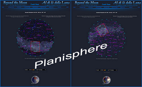
| The rapresentation of the Tabulae Coeli (fig. 1) (follow the exarmple below) is intended to be a different popular form for an original sight of the sky and of the main astronomical objects. The photographic images are grouped as in an astronomical atlas ordered by RA and Dec and can be identified and reached through four different interactive Planispheres: Borealis Planisphere, Ecliptical 00h-12h, Ecliptical 12h-00h, and Australis Planisphere (fig.1). |
|
La rappresentazione delle Tabulae Coeli (fig. 1) (seguire le figure di esempio sotto riportate) vuole essere una diversa forma divulgativa per una originale visione del cielo e dei principali oggetti astronomici. Le immagini fotografiche sono raggruppate come in un atlante astronomico per ordine di AR e Dec e possono essere individuate e raggiunte attraverso quattro Planisferi interattivi distinti che sono: Borealis Planisphere, Ecliptical 00h-12h, Ecliptical 12h-00h e Australis Planisphere (fig. 1). |
| |
|
|
|
|
|
fig. 1 |
|
fig. 1 |
|
|
|
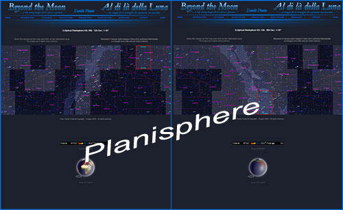
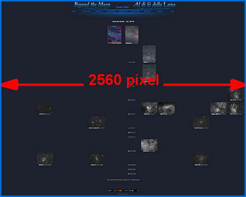
The Tabulae Coeli pages measured 2560 pixels (fig. 3), in width, so pay attention when using the horizontal scrolling bars, especially if the monitor does not support that resolution. Each page of Tabulae Coeli (fig. 2) contains a simple map (Map), taken from the Planisphere, at the top center, and its corresponding framing in wide-field photography on the right. Subsequent images, at higher magnification, develop from each of the wide-field photographs, in a vertical sequence (high > low), depending on the number of deep-sky objects contained in the wide-field area. These successive frames, obtained with optics with different focal lenght (rollower fig. 2), see also section INTRODUCTION > Equipment, show most of the astronomical objects (nebulae, clusters and galaxies) with a higher resolution. By clicking on each of these previews it is possible to see the same image at a higher resolution. Each preview displays: the name of the object, the type of filter and the apparent field, in decimal degrees of the framing (FOV). Moreover, in fig.2 rollower, you can understand that the horizontal and vertical development of the Tabulae Coeli is closely connected to the object types and the lenses focal lengths used for photographs. As well as each row is a specific instrument, each column is a deep-sky object. |
|
Le pagine delle Tabulae Coeli misurano in larghezza 2560 pixel (fig.3), quindi attenzione a fare uso delle barre per lo scrolling in orizzontale, in particolare se il monitor non supporta tale risoluzione. Ogni pagina delle Tabulae Coeli (fig. 2) si apre al centro in alto con una semplice mappa (Map) che riprende da una parte la mappa del Planisfero e dall'altra l'adiacente inquadratura della fotografia a grande campo. Da ognuna di queste fotografie si sviluppano in sequenza verticale (alto > basso) le successive immagini a maggiore ingrandimento dipendenti dal numero di oggetti deep-sky inclusi nella area wide-field. Queste successive inquadrature, ottenute con ottiche a focali diverse (rollower fig.2), vedere anche la sezione INTRODUCTION > Equipment, illustrano con migliore definizione la maggior parte degli oggetti astronomici (nebulose, ammassi e galassie) contenuti nelle wide-field. Per ciascuna anteprima viene indicato: il nome del soggetto, il tipo di filtro e il campo apparente, in gradi decimali dell'inquadratura (FOV). Sempre in fig.2 rollower, è possibile intuire come lo sviluppo in orizzontale e in verticale delle Tabulae Coeli sia strettamente collegato tra i tipi di oggetti e le focali delle lenti usate per le fotografie. Così come ad ogni riga corrisponde uno strumento specifico, mentre ad ogni colonna un oggetto deep-sky |
|
|
|
|
| |
|
|
Fig. 2 |
| |
|
|
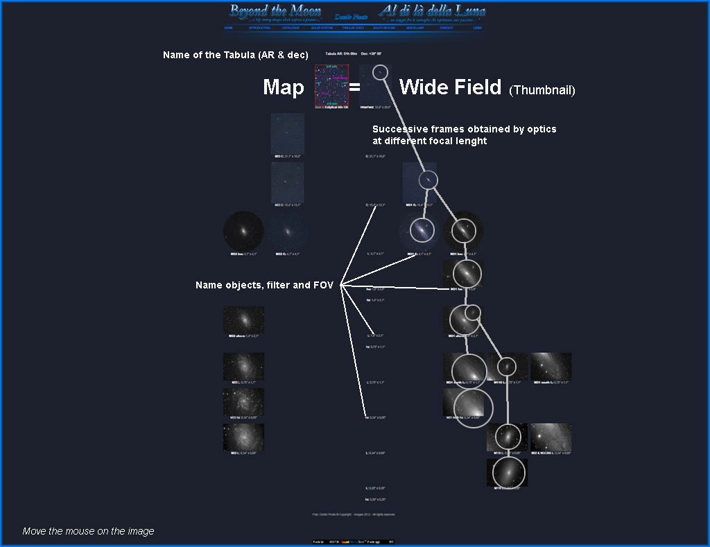
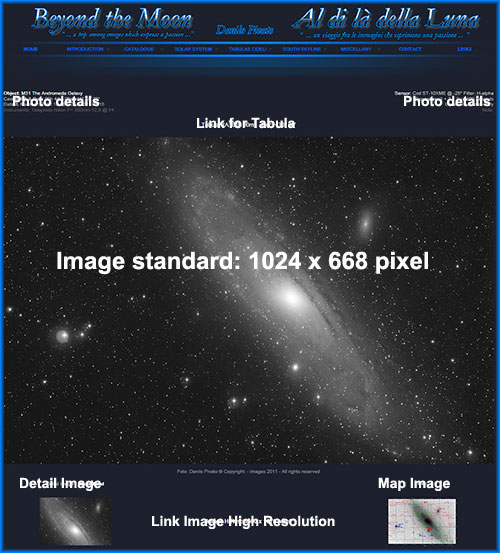
| Making click on every of these previews is possible to see the standard image: 1024x668 pixel (fig.4). In the top of the page they are suitable the technical characteristics of the employed instrumentation, the place where the photographic release and the characteristics of the resumptions have been performed. To the of under of every standard image, there are 2 previews related to a detail image in real pixel, when possible, of the shot and the corresponding map. Making click on each of these previews is accessed at the image. Click on the writing in low to the center, Hires .... x .... it is accessed the image in high resolution.The page with the map is characterized, on the right, by the legenda where are the graphic symbols divided for types of objects and for dimensions, while to the left, when it present, the link to view the map in high resolution. |
|
Facendo click su ciascuna di queste anteprime è possibile vedere la stessa immagine a risoluzione standard: 1024x668 pixel (fig. 4). Nella parte in alto della pagina sono indicate le caratteristiche tecniche della strumentazione impiegata, le caratteristiche delle riprese e la località in cui è stato eseguito lo scatto fotografico. Al di sotto di ciascuna immagine standard vengono riportate 2 anteprime relative a un dettaglio in pixel reali quando e la corrispettiva mappa. Facendo click su ognuna di queste anteprime si accede alla corrispettiva immagine dell'anteprima. Cliccando invece sulla scritta in basso al centro, Image Hires: 1600x1076 pixel, si accede all'immagine in alta risoluzione. La pagina con la mappa è caratterizzata sulla destra dalla legenda, ove sono indicati i simboli grafici suddivisi per tipi di oggetti e per dimensioni, mentre in alto a sinistra dal link, quando presente, per visionare la mappa in alta risoluzione |
| |
|
|
|
|
Fig. 3 |
Fig. 4 |
| |
|
| |
|
The summary and index of all the deep-sky photographs included in Tabulae Coeli is the page called: Index Phot & Maps, (in addition to the section CATALOGUE where are divided by the most famous existing catalogs).
Here you will find all the thumbnails of the photos and maps ordered mainly for Right Ascension (RA) and Tabulae. Each of these thumbnails is connected with the relative standard image and flank are reported, in addition to the preliminary technical data, link for direct access to the corresponding page of the Tabula. (Continue...) |
|
Il riepilogo e l'indice di tutte le fotografie deep-sky inserite nelle Tabulae Coeli è costituito dalla pagina denominata: Index Phot & Maps (oltre all'apposita sezione CATALOGUE dove sono invece suddivise per i più famosi cataloghi esistenti).
Qui sono riportate tutte le anteprime delle foto e delle mappe, ordinate principalmente per Ascensione Retta (AR) e per Tabulae. Ciascuna di queste anteprime è collegata con la relativa immagine standard e di fianco sono riportati, oltre ai dati tecnici preliminari, il link diretto per accedere alla corrispettiva pagina della Tabula. (Continua...) |
| |
|
|
| |
|
|
| |
|
|
| |
|
|
| |
|
|
| |
|
|
| |
|
|
| |
|
|
| |
|
|
| |
|
|
| |
|
|
| |
|
|
| |
|
|
| |
|
|
| |
|
|
| |
|
|
| |
|
|
|